Satellite
-
 KAIST’s Next-Generation Small Satellite-2 Completes a Two-Year Mission – the Successful Observation of Arctic and Forest Changes
KAIST (President Kwang-Hyung Lee) announced on the 25th of May that the Next-Generation Small Satellite-2 developed by the Satellite Technology Research Center (SaTReC, Director Jaeheung Han) and launched aboard the third Nuri rocket from the Naro Space Center at 18:24 on May 25, 2023, has successfully completed its two-year core mission of verifying homegrown Synthetic Aperture Radar (SAR) technology and conducting all-weather Earth observations.
The SAR system onboard the satellite was designed, manufactured, and tested domestically for the first time by KAIST’s Satellite Research Center. As of May 25, 2025, it has successfully completed its two-year in-orbit technology demonstration mission.
Particularly noteworthy is the fact that the SAR system was mounted on the 100 kg-class Next-Generation Small Satellite-2, marking a major step forward in the miniaturization and weight reduction of spaceborne radar systems and strengthening Korea’s competitiveness in satellite technology.
< Figure 1. Conceptual diagram of Earth observation by the Next-Generation Small Satellite No. 2's synthetic aperture radar >
The developed SAR is an active sensor that uses electromagnetic waves, allowing all-weather image acquisition regardless of time of day or weather conditions. This makes it especially useful for monitoring regions like the Korean Peninsula, which frequently experiences rain and cloud cover, as it can observe even in cloudy and rainy conditions or darkness.
Since its launch, the satellite has carried out three to four image acquisitions per day on average, undergoing functionality checks and technology verifications. To date, it has completed over 1,200 Earth observations and the SAR continues to perform stably, supporting ongoing observation tasks even beyond its designated mission lifespan.
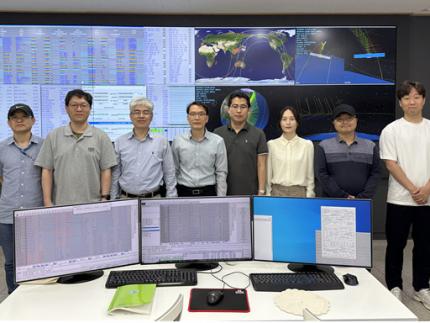
< Photo 1. Researchers of the Next-Generation Small Satellite No. 2 at SatRec, taken at the KAIST ground station. (From left) Sung-Og Park, Jung-soo Lee, Hongyoung Park, TaeSeong Jang (Next-Generation Small Satellite No. 2 Project Manager), Seyeon Kim, Mi Young Park, Yongmin Kim, DongGuk Kim >
Although still in the domestic technology verification stage, KAIST’s Satellite Research Center has been collaborating with the Korea Polar Research Institute (Director Hyoung Chul Shin) and the Korea National Park Research Institute (Director Jin Tae Kim) since March 2024 to prioritize imaging of areas of interest related to Arctic ice changes and forest ecosystem monitoring.
KAIST’s Satellite Research Center is conducting repeated observations of Arctic sea ice, and the Remote Sensing and Cryosphere Information Center of the Korea Polar Research Institute is analyzing the results using time-series data to precisely track changes in sea ice area and structure due to climate change.
< Photo 2. Radar Images from Observations on July 24, 2024 - Around the Atchafalaya River in Louisiana, USA. The Wax Lake Delta is seen growing like a leaf. >
Recently, the Korea Polar Research Institute (KOPRI), by integrating observation data from the Next-Generation Small Satellite No. 2 and the European Space Agency's (ESA) Sentinel-1, detected a significant increase of 15 km² in the area of an ice lake behind Canada's Milne Ice Shelf (a massive, floating layer of ice where glaciers flow from land into the sea) between 2021 and 2025. This has exacerbated structural instability and is analyzed as an important sign indicating the acceleration of Arctic climate change.
Hyuncheol Kim, Director of the Remote Sensing and Cryosphere Information Center at the Korea Polar Research Institute, stated, “This research clearly demonstrates how vulnerable Arctic ice shelves are to climate change. We will continue to monitor and analyze Arctic environmental changes using the SAR aboard the Next-Generation Small Satellite-2 and promote international collaboration.” He added, “We also plan to present these findings at international academic conferences and expand educational and outreach efforts to raise public awareness about changes in the Arctic environment.”
< Photo 3. Sinduri Coastal Dune, Taean Coastal National Park, Taean-gun, Chungcheongnam-do >
In collaboration with the Climate Change Research Center of the National Park Research Institute, SAR imagery from the satellite is also being used to study phenological shifts due to climate change, the dieback of conifers in high-altitude zones, and landslide monitoring in forest ecosystems. Researchers are also analyzing the spatial distribution of carbon storage in forest areas using satellite data, comparing it with field measurements to improve accuracy.
Because SAR is unaffected by light and weather conditions, it can observe through fire and smoke during wildfires, making it an exceptionally effective tool for the regular monitoring of large protected areas. It is expected to play an important role in shaping future forest conservation policies.
In addition, KAIST’s Satellite Research Center is working on a system to convert the satellite’s technology demonstration data into standardized imagery products, with budget support from the Korea Aerospace Administration (Administrator Youngbin Yoon), making the data more accessible to research institutions and boosting the usability of the satellite’s observations.
< Photo 4. Jang Bogo Station, Antarctica >
Jaeheung Han, Director of the Satellite Research Center, said, “The significance of the Next-Generation Small Satellite-2 lies not only in the success of domestic development, but also in its direct contribution to real-world environmental analysis and national research efforts. We will continue to focus on expanding the application of SAR data from the satellite.”
KAIST President Kwang-Hyung Lee remarked, “This satellite is a product of KAIST’s advanced space technology and the innovation capacity of its researchers. Its success signals KAIST’s potential to lead in future space technology talent development and R&D, and we will continue to accelerate efforts in this direction.”
< Photo 5. Confirmation of changes in the expanded area of the Milne Ice Shelf lake using observation data from Next-Generation Small Satellite No. 2 and Sentinel-1 >
2025.05.25 View 1581
KAIST’s Next-Generation Small Satellite-2 Completes a Two-Year Mission – the Successful Observation of Arctic and Forest Changes
KAIST (President Kwang-Hyung Lee) announced on the 25th of May that the Next-Generation Small Satellite-2 developed by the Satellite Technology Research Center (SaTReC, Director Jaeheung Han) and launched aboard the third Nuri rocket from the Naro Space Center at 18:24 on May 25, 2023, has successfully completed its two-year core mission of verifying homegrown Synthetic Aperture Radar (SAR) technology and conducting all-weather Earth observations.
The SAR system onboard the satellite was designed, manufactured, and tested domestically for the first time by KAIST’s Satellite Research Center. As of May 25, 2025, it has successfully completed its two-year in-orbit technology demonstration mission.
Particularly noteworthy is the fact that the SAR system was mounted on the 100 kg-class Next-Generation Small Satellite-2, marking a major step forward in the miniaturization and weight reduction of spaceborne radar systems and strengthening Korea’s competitiveness in satellite technology.
< Figure 1. Conceptual diagram of Earth observation by the Next-Generation Small Satellite No. 2's synthetic aperture radar >
The developed SAR is an active sensor that uses electromagnetic waves, allowing all-weather image acquisition regardless of time of day or weather conditions. This makes it especially useful for monitoring regions like the Korean Peninsula, which frequently experiences rain and cloud cover, as it can observe even in cloudy and rainy conditions or darkness.
Since its launch, the satellite has carried out three to four image acquisitions per day on average, undergoing functionality checks and technology verifications. To date, it has completed over 1,200 Earth observations and the SAR continues to perform stably, supporting ongoing observation tasks even beyond its designated mission lifespan.
< Photo 1. Researchers of the Next-Generation Small Satellite No. 2 at SatRec, taken at the KAIST ground station. (From left) Sung-Og Park, Jung-soo Lee, Hongyoung Park, TaeSeong Jang (Next-Generation Small Satellite No. 2 Project Manager), Seyeon Kim, Mi Young Park, Yongmin Kim, DongGuk Kim >
Although still in the domestic technology verification stage, KAIST’s Satellite Research Center has been collaborating with the Korea Polar Research Institute (Director Hyoung Chul Shin) and the Korea National Park Research Institute (Director Jin Tae Kim) since March 2024 to prioritize imaging of areas of interest related to Arctic ice changes and forest ecosystem monitoring.
KAIST’s Satellite Research Center is conducting repeated observations of Arctic sea ice, and the Remote Sensing and Cryosphere Information Center of the Korea Polar Research Institute is analyzing the results using time-series data to precisely track changes in sea ice area and structure due to climate change.
< Photo 2. Radar Images from Observations on July 24, 2024 - Around the Atchafalaya River in Louisiana, USA. The Wax Lake Delta is seen growing like a leaf. >
Recently, the Korea Polar Research Institute (KOPRI), by integrating observation data from the Next-Generation Small Satellite No. 2 and the European Space Agency's (ESA) Sentinel-1, detected a significant increase of 15 km² in the area of an ice lake behind Canada's Milne Ice Shelf (a massive, floating layer of ice where glaciers flow from land into the sea) between 2021 and 2025. This has exacerbated structural instability and is analyzed as an important sign indicating the acceleration of Arctic climate change.
Hyuncheol Kim, Director of the Remote Sensing and Cryosphere Information Center at the Korea Polar Research Institute, stated, “This research clearly demonstrates how vulnerable Arctic ice shelves are to climate change. We will continue to monitor and analyze Arctic environmental changes using the SAR aboard the Next-Generation Small Satellite-2 and promote international collaboration.” He added, “We also plan to present these findings at international academic conferences and expand educational and outreach efforts to raise public awareness about changes in the Arctic environment.”
< Photo 3. Sinduri Coastal Dune, Taean Coastal National Park, Taean-gun, Chungcheongnam-do >
In collaboration with the Climate Change Research Center of the National Park Research Institute, SAR imagery from the satellite is also being used to study phenological shifts due to climate change, the dieback of conifers in high-altitude zones, and landslide monitoring in forest ecosystems. Researchers are also analyzing the spatial distribution of carbon storage in forest areas using satellite data, comparing it with field measurements to improve accuracy.
Because SAR is unaffected by light and weather conditions, it can observe through fire and smoke during wildfires, making it an exceptionally effective tool for the regular monitoring of large protected areas. It is expected to play an important role in shaping future forest conservation policies.
In addition, KAIST’s Satellite Research Center is working on a system to convert the satellite’s technology demonstration data into standardized imagery products, with budget support from the Korea Aerospace Administration (Administrator Youngbin Yoon), making the data more accessible to research institutions and boosting the usability of the satellite’s observations.
< Photo 4. Jang Bogo Station, Antarctica >
Jaeheung Han, Director of the Satellite Research Center, said, “The significance of the Next-Generation Small Satellite-2 lies not only in the success of domestic development, but also in its direct contribution to real-world environmental analysis and national research efforts. We will continue to focus on expanding the application of SAR data from the satellite.”
KAIST President Kwang-Hyung Lee remarked, “This satellite is a product of KAIST’s advanced space technology and the innovation capacity of its researchers. Its success signals KAIST’s potential to lead in future space technology talent development and R&D, and we will continue to accelerate efforts in this direction.”
< Photo 5. Confirmation of changes in the expanded area of the Milne Ice Shelf lake using observation data from Next-Generation Small Satellite No. 2 and Sentinel-1 >
2025.05.25 View 1581 -
 North Korea and Beyond: AI-Powered Satellite Analysis Reveals the Unseen Economic Landscape of Underdeveloped Nations
- A joint research team in computer science, economics, and geography has developed an artificial intelligence (AI) technology to measure grid-level economic development within six-square-kilometer regions.
- This AI technology is applicable in regions with limited statistical data (e.g., North Korea), supporting international efforts to propose policies for economic growth and poverty reduction in underdeveloped countries.
- The research team plans to make this technology freely available for use to contribute to the United Nations' Sustainable Development Goals (SDGs).
The United Nations reports that more than 700 million people are in extreme poverty, earning less than two dollars a day. However, an accurate assessment of poverty remains a global challenge. For example, 53 countries have not conducted agricultural surveys in the past 15 years, and 17 countries have not published a population census. To fill this data gap, new technologies are being explored to estimate poverty using alternative sources such as street views, aerial photos, and satellite images.
The paper published in Nature Communications demonstrates how artificial intelligence (AI) can help analyze economic conditions from daytime satellite imagery. This new technology can even apply to the least developed countries - such as North Korea - that do not have reliable statistical data for typical machine learning training.
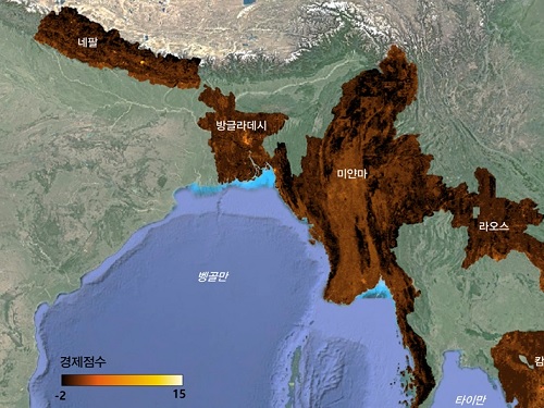
The researchers used Sentinel-2 satellite images from the European Space Agency (ESA) that are publicly available. They split these images into small six-square-kilometer grids. At this zoom level, visual information such as buildings, roads, and greenery can be used to quantify economic indicators. As a result, the team obtained the first ever fine-grained economic map of regions like North Korea. The same algorithm was applied to other underdeveloped countries in Asia: North Korea, Nepal, Laos, Myanmar, Bangladesh, and Cambodia (see Image 1).
The key feature of their research model is the "human-machine collaborative approach," which lets researchers combine human input with AI predictions for areas with scarce data. In this research, ten human experts compared satellite images and judged the economic conditions in the area, with the AI learning from this human data and giving economic scores to each image. The results showed that the Human-AI collaborative approach outperformed machine-only learning algorithms.
< Image 1. Nightlight satellite images of North Korea (Top-left: Background photo provided by NASA's Earth Observatory). South Korea appears brightly lit compared to North Korea, which is mostly dark except for Pyongyang. In contrast, the model developed by the research team uses daytime satellite imagery to predict more detailed economic predictions for North Korea (top-right) and five Asian countries (Bottom: Background photo from Google Earth). >
The research was led by an interdisciplinary team of computer scientists, economists, and a geographer from KAIST & IBS (Donghyun Ahn, Meeyoung Cha, Jihee Kim), Sogang University (Hyunjoo Yang), HKUST (Sangyoon Park), and NUS (Jeasurk Yang). Dr Charles Axelsson, Associate Editor at Nature Communications, handled this paper during the peer review process at the journal.
The research team found that the scores showed a strong correlation with traditional socio-economic metrics such as population density, employment, and number of businesses. This demonstrates the wide applicability and scalability of the approach, particularly in data-scarce countries. Furthermore, the model's strength lies in its ability to detect annual changes in economic conditions at a more detailed geospatial level without using any survey data (see Image 2).
< Image 2. Differences in satellite imagery and economic scores in North Korea between 2016 and 2019. Significant development was found in the Wonsan Kalma area (top), one of the tourist development zones, but no changes were observed in the Wiwon Industrial Development Zone (bottom). (Background photo: Sentinel-2 satellite imagery provided by the European Space Agency (ESA)). >
This model would be especially valuable for rapidly monitoring the progress of Sustainable Development Goals such as reducing poverty and promoting more equitable and sustainable growth on an international scale. The model can also be adapted to measure various social and environmental indicators. For example, it can be trained to identify regions with high vulnerability to climate change and disasters to provide timely guidance on disaster relief efforts.
As an example, the researchers explored how North Korea changed before and after the United Nations sanctions against the country. By applying the model to satellite images of North Korea both in 2016 and in 2019, the researchers discovered three key trends in the country's economic development between 2016 and 2019. First, economic growth in North Korea became more concentrated in Pyongyang and major cities, exacerbating the urban-rural divide. Second, satellite imagery revealed significant changes in areas designated for tourism and economic development, such as new building construction and other meaningful alterations. Third, traditional industrial and export development zones showed relatively minor changes.
Meeyoung Cha, a data scientist in the team explained, "This is an important interdisciplinary effort to address global challenges like poverty. We plan to apply our AI algorithm to other international issues, such as monitoring carbon emissions, disaster damage detection, and the impact of climate change."
An economist on the research team, Jihee Kim, commented that this approach would enable detailed examinations of economic conditions in the developing world at a low cost, reducing data disparities between developed and developing nations. She further emphasized that this is most essential because many public policies require economic measurements to achieve their goals, whether they are for growth, equality, or sustainability.
The research team has made the source code publicly available via GitHub and plans to continue improving the technology, applying it to new satellite images updated annually. The results of this study, with Ph.D. candidate Donghyun Ahn at KAIST and Ph.D. candidate Jeasurk Yang at NUS as joint first authors, were published in Nature Communications under the title "A human-machine collaborative approach measures economic development using satellite imagery."
< Photos of the main authors. 1. Donghyun Ahn, PhD candidate at KAIST School of Computing 2. Jeasurk Yang, PhD candidate at the Department of Geography of National University of Singapore 3. Meeyoung Cha, Professor of KAIST School of Computing and CI at IBS 4. Jihee Kim, Professor of KAIST School of Business and Technology Management 5. Sangyoon Park, Professor of the Division of Social Science at Hong Kong University of Science and Technology 6. Hyunjoo Yang, Professor of the Department of Economics at Sogang University >
2023.12.07 View 9056
North Korea and Beyond: AI-Powered Satellite Analysis Reveals the Unseen Economic Landscape of Underdeveloped Nations
- A joint research team in computer science, economics, and geography has developed an artificial intelligence (AI) technology to measure grid-level economic development within six-square-kilometer regions.
- This AI technology is applicable in regions with limited statistical data (e.g., North Korea), supporting international efforts to propose policies for economic growth and poverty reduction in underdeveloped countries.
- The research team plans to make this technology freely available for use to contribute to the United Nations' Sustainable Development Goals (SDGs).
The United Nations reports that more than 700 million people are in extreme poverty, earning less than two dollars a day. However, an accurate assessment of poverty remains a global challenge. For example, 53 countries have not conducted agricultural surveys in the past 15 years, and 17 countries have not published a population census. To fill this data gap, new technologies are being explored to estimate poverty using alternative sources such as street views, aerial photos, and satellite images.
The paper published in Nature Communications demonstrates how artificial intelligence (AI) can help analyze economic conditions from daytime satellite imagery. This new technology can even apply to the least developed countries - such as North Korea - that do not have reliable statistical data for typical machine learning training.
The researchers used Sentinel-2 satellite images from the European Space Agency (ESA) that are publicly available. They split these images into small six-square-kilometer grids. At this zoom level, visual information such as buildings, roads, and greenery can be used to quantify economic indicators. As a result, the team obtained the first ever fine-grained economic map of regions like North Korea. The same algorithm was applied to other underdeveloped countries in Asia: North Korea, Nepal, Laos, Myanmar, Bangladesh, and Cambodia (see Image 1).
The key feature of their research model is the "human-machine collaborative approach," which lets researchers combine human input with AI predictions for areas with scarce data. In this research, ten human experts compared satellite images and judged the economic conditions in the area, with the AI learning from this human data and giving economic scores to each image. The results showed that the Human-AI collaborative approach outperformed machine-only learning algorithms.
< Image 1. Nightlight satellite images of North Korea (Top-left: Background photo provided by NASA's Earth Observatory). South Korea appears brightly lit compared to North Korea, which is mostly dark except for Pyongyang. In contrast, the model developed by the research team uses daytime satellite imagery to predict more detailed economic predictions for North Korea (top-right) and five Asian countries (Bottom: Background photo from Google Earth). >
The research was led by an interdisciplinary team of computer scientists, economists, and a geographer from KAIST & IBS (Donghyun Ahn, Meeyoung Cha, Jihee Kim), Sogang University (Hyunjoo Yang), HKUST (Sangyoon Park), and NUS (Jeasurk Yang). Dr Charles Axelsson, Associate Editor at Nature Communications, handled this paper during the peer review process at the journal.
The research team found that the scores showed a strong correlation with traditional socio-economic metrics such as population density, employment, and number of businesses. This demonstrates the wide applicability and scalability of the approach, particularly in data-scarce countries. Furthermore, the model's strength lies in its ability to detect annual changes in economic conditions at a more detailed geospatial level without using any survey data (see Image 2).
< Image 2. Differences in satellite imagery and economic scores in North Korea between 2016 and 2019. Significant development was found in the Wonsan Kalma area (top), one of the tourist development zones, but no changes were observed in the Wiwon Industrial Development Zone (bottom). (Background photo: Sentinel-2 satellite imagery provided by the European Space Agency (ESA)). >
This model would be especially valuable for rapidly monitoring the progress of Sustainable Development Goals such as reducing poverty and promoting more equitable and sustainable growth on an international scale. The model can also be adapted to measure various social and environmental indicators. For example, it can be trained to identify regions with high vulnerability to climate change and disasters to provide timely guidance on disaster relief efforts.
As an example, the researchers explored how North Korea changed before and after the United Nations sanctions against the country. By applying the model to satellite images of North Korea both in 2016 and in 2019, the researchers discovered three key trends in the country's economic development between 2016 and 2019. First, economic growth in North Korea became more concentrated in Pyongyang and major cities, exacerbating the urban-rural divide. Second, satellite imagery revealed significant changes in areas designated for tourism and economic development, such as new building construction and other meaningful alterations. Third, traditional industrial and export development zones showed relatively minor changes.
Meeyoung Cha, a data scientist in the team explained, "This is an important interdisciplinary effort to address global challenges like poverty. We plan to apply our AI algorithm to other international issues, such as monitoring carbon emissions, disaster damage detection, and the impact of climate change."
An economist on the research team, Jihee Kim, commented that this approach would enable detailed examinations of economic conditions in the developing world at a low cost, reducing data disparities between developed and developing nations. She further emphasized that this is most essential because many public policies require economic measurements to achieve their goals, whether they are for growth, equality, or sustainability.
The research team has made the source code publicly available via GitHub and plans to continue improving the technology, applying it to new satellite images updated annually. The results of this study, with Ph.D. candidate Donghyun Ahn at KAIST and Ph.D. candidate Jeasurk Yang at NUS as joint first authors, were published in Nature Communications under the title "A human-machine collaborative approach measures economic development using satellite imagery."
< Photos of the main authors. 1. Donghyun Ahn, PhD candidate at KAIST School of Computing 2. Jeasurk Yang, PhD candidate at the Department of Geography of National University of Singapore 3. Meeyoung Cha, Professor of KAIST School of Computing and CI at IBS 4. Jihee Kim, Professor of KAIST School of Business and Technology Management 5. Sangyoon Park, Professor of the Division of Social Science at Hong Kong University of Science and Technology 6. Hyunjoo Yang, Professor of the Department of Economics at Sogang University >
2023.12.07 View 9056 -
 KAIST & LG U+ Team Up for Quantum Computing Solution for Ultra-Space 6G Satellite Networking
KAIST quantum computer scientists have optimized ultra-space 6G Low-Earth Orbit (LEO) satellite networking, finding the shortest path to transfer data from a city to another place via multi-satellite hops.
The research team led by Professor June-Koo Kevin Rhee and Professor Dongsu Han in partnership with LG U+ verified the possibility of ultra-performance and precision communication with satellite networks using D-Wave, the first commercialized quantum computer.
Satellite network optimization has remained challenging since the network needs to be reconfigured whenever satellites approach other satellites within the connection range in a three-dimensional space. Moreover, LEO satellites orbiting at 200~2000 km above the Earth change their positions dynamically, whereas Geo-Stationary Orbit (GSO) satellites do not change their positions. Thus, LEO satellite network optimization needs to be solved in real time.
The research groups formulated the problem as a Quadratic Unconstrained Binary Optimization (QUBO) problem and managed to solve the problem, incorporating the connectivity and link distance limits as the constraints.
The proposed optimization algorithm is reported to be much more efficient in terms of hop counts and path length than previously reported studies using classical solutions. These results verify that a satellite network can provide ultra-performance (over 1Gbps user-perceived speed), and ultra-precision (less than 5ms end-to-end latency) network services, which are comparable to terrestrial communication.
Once QUBO is applied, “ultra-space networking” is expected to be realized with 6G. Researchers said that an ultra-space network provides communication services for an object moving at up to 10 km altitude with an extreme speed (~ 1000 km/h). Optimized LEO satellite networks can provide 6G communication services to currently unavailable areas such as air flights and deserts.
Professor Rhee, who is also the CEO of Qunova Computing, noted, “Collaboration with LG U+ was meaningful as we were able to find an industrial application for a quantum computer. We look forward to more quantum application research on real problems such as in communications, drug and material discovery, logistics, and fintech industries.”
2022.06.17 View 10237
KAIST & LG U+ Team Up for Quantum Computing Solution for Ultra-Space 6G Satellite Networking
KAIST quantum computer scientists have optimized ultra-space 6G Low-Earth Orbit (LEO) satellite networking, finding the shortest path to transfer data from a city to another place via multi-satellite hops.
The research team led by Professor June-Koo Kevin Rhee and Professor Dongsu Han in partnership with LG U+ verified the possibility of ultra-performance and precision communication with satellite networks using D-Wave, the first commercialized quantum computer.
Satellite network optimization has remained challenging since the network needs to be reconfigured whenever satellites approach other satellites within the connection range in a three-dimensional space. Moreover, LEO satellites orbiting at 200~2000 km above the Earth change their positions dynamically, whereas Geo-Stationary Orbit (GSO) satellites do not change their positions. Thus, LEO satellite network optimization needs to be solved in real time.
The research groups formulated the problem as a Quadratic Unconstrained Binary Optimization (QUBO) problem and managed to solve the problem, incorporating the connectivity and link distance limits as the constraints.
The proposed optimization algorithm is reported to be much more efficient in terms of hop counts and path length than previously reported studies using classical solutions. These results verify that a satellite network can provide ultra-performance (over 1Gbps user-perceived speed), and ultra-precision (less than 5ms end-to-end latency) network services, which are comparable to terrestrial communication.
Once QUBO is applied, “ultra-space networking” is expected to be realized with 6G. Researchers said that an ultra-space network provides communication services for an object moving at up to 10 km altitude with an extreme speed (~ 1000 km/h). Optimized LEO satellite networks can provide 6G communication services to currently unavailable areas such as air flights and deserts.
Professor Rhee, who is also the CEO of Qunova Computing, noted, “Collaboration with LG U+ was meaningful as we were able to find an industrial application for a quantum computer. We look forward to more quantum application research on real problems such as in communications, drug and material discovery, logistics, and fintech industries.”
2022.06.17 View 10237 -
 ‘Urban Green Space Affects Citizens’ Happiness’
Study finds the relationship between green space, the economy, and happiness
A recent study revealed that as a city becomes more economically developed, its citizens’ happiness becomes more directly related to the area of urban green space.
A joint research project by Professor Meeyoung Cha of the School of Computing and her collaborators studied the relationship between green space and citizen happiness by analyzing big data from satellite images of 60 different countries.
Urban green space, including parks, gardens, and riversides not only provides aesthetic pleasure, but also positively affects our health by promoting physical activity and social interactions. Most of the previous research attempting to verify the correlation between urban green space and citizen happiness was based on few developed countries. Therefore, it was difficult to identify whether the positive effects of green space are global, or merely phenomena that depended on the economic state of the country. There have also been limitations in data collection, as it is difficult to visit each location or carry out investigations on a large scale based on aerial photographs.
The research team used data collected by Sentinel-2, a high-resolution satellite operated by the European Space Agency (ESA) to investigate 90 green spaces from 60 different countries around the world. The subjects of analysis were cities with the highest population densities (cities that contain at least 10% of the national population), and the images were obtained during the summer of each region for clarity. Images from the northern hemisphere were obtained between June and September of 2018, and those from the southern hemisphere were obtained between December of 2017 and February of 2018.
The areas of urban green space were then quantified and crossed with data from the World Happiness Report and GDP by country reported by the United Nations in 2018. Using these data, the relationships between green space, the economy, and citizen happiness were analyzed.
The results showed that in all cities, citizen happiness was positively correlated with the area of urban green space regardless of the country’s economic state. However, out of the 60 countries studied, the happiness index of the bottom 30 by GDP showed a stronger correlation with economic growth. In countries whose gross national income (GDP per capita) was higher than 38,000 USD, the area of green space acted as a more important factor affecting happiness than economic growth. Data from Seoul was analyzed to represent South Korea, and showed an increased happiness index with increased green areas compared to the past.
The authors point out their work has several policy-level implications. First, public green space should be made accessible to urban dwellers to enhance social support. If public safety in urban parks is not guaranteed, its positive role in social support and happiness may diminish. Also, the meaning of public safety may change; for example, ensuring biological safety will be a priority in keeping urban parks accessible during the COVID-19 pandemic.
Second, urban planning for public green space is needed for both developed and developing countries. As it is challenging or nearly impossible to secure land for green space after the area is developed, urban planning for parks and green space should be considered in developing economies where new cities and suburban areas are rapidly expanding.
Third, recent climate changes can present substantial difficulty in sustaining urban green space. Extreme events such as wildfires, floods, droughts, and cold waves could endanger urban forests while global warming could conversely accelerate tree growth in cities due to the urban heat island effect. Thus, more attention must be paid to predict climate changes and discovering their impact on the maintenance of urban green space.
“There has recently been an increase in the number of studies using big data from satellite images to solve social conundrums,” said Professor Cha. “The tool developed for this investigation can also be used to quantify the area of aquatic environments like lakes and the seaside, and it will now be possible to analyze the relationship between citizen happiness and aquatic environments in future studies,” she added.
Professor Woo Sung Jung from POSTECH and Professor Donghee Wohn from the New Jersey Institute of Technology also joined this research. It was reported in the online issue of EPJ Data Science on May 30.
-PublicationOh-Hyun Kwon, Inho Hong, Jeasurk Yang, Donghee Y. Wohn, Woo-Sung Jung, andMeeyoung Cha, 2021. Urban green space and happiness in developed countries. EPJ Data Science. DOI: https://doi.org/10.1140/epjds/s13688-021-00278-7
-ProfileProfessor Meeyoung ChaData Science Labhttps://ds.ibs.re.kr/
School of Computing
KAIST
2021.06.21 View 13315
‘Urban Green Space Affects Citizens’ Happiness’
Study finds the relationship between green space, the economy, and happiness
A recent study revealed that as a city becomes more economically developed, its citizens’ happiness becomes more directly related to the area of urban green space.
A joint research project by Professor Meeyoung Cha of the School of Computing and her collaborators studied the relationship between green space and citizen happiness by analyzing big data from satellite images of 60 different countries.
Urban green space, including parks, gardens, and riversides not only provides aesthetic pleasure, but also positively affects our health by promoting physical activity and social interactions. Most of the previous research attempting to verify the correlation between urban green space and citizen happiness was based on few developed countries. Therefore, it was difficult to identify whether the positive effects of green space are global, or merely phenomena that depended on the economic state of the country. There have also been limitations in data collection, as it is difficult to visit each location or carry out investigations on a large scale based on aerial photographs.
The research team used data collected by Sentinel-2, a high-resolution satellite operated by the European Space Agency (ESA) to investigate 90 green spaces from 60 different countries around the world. The subjects of analysis were cities with the highest population densities (cities that contain at least 10% of the national population), and the images were obtained during the summer of each region for clarity. Images from the northern hemisphere were obtained between June and September of 2018, and those from the southern hemisphere were obtained between December of 2017 and February of 2018.
The areas of urban green space were then quantified and crossed with data from the World Happiness Report and GDP by country reported by the United Nations in 2018. Using these data, the relationships between green space, the economy, and citizen happiness were analyzed.
The results showed that in all cities, citizen happiness was positively correlated with the area of urban green space regardless of the country’s economic state. However, out of the 60 countries studied, the happiness index of the bottom 30 by GDP showed a stronger correlation with economic growth. In countries whose gross national income (GDP per capita) was higher than 38,000 USD, the area of green space acted as a more important factor affecting happiness than economic growth. Data from Seoul was analyzed to represent South Korea, and showed an increased happiness index with increased green areas compared to the past.
The authors point out their work has several policy-level implications. First, public green space should be made accessible to urban dwellers to enhance social support. If public safety in urban parks is not guaranteed, its positive role in social support and happiness may diminish. Also, the meaning of public safety may change; for example, ensuring biological safety will be a priority in keeping urban parks accessible during the COVID-19 pandemic.
Second, urban planning for public green space is needed for both developed and developing countries. As it is challenging or nearly impossible to secure land for green space after the area is developed, urban planning for parks and green space should be considered in developing economies where new cities and suburban areas are rapidly expanding.
Third, recent climate changes can present substantial difficulty in sustaining urban green space. Extreme events such as wildfires, floods, droughts, and cold waves could endanger urban forests while global warming could conversely accelerate tree growth in cities due to the urban heat island effect. Thus, more attention must be paid to predict climate changes and discovering their impact on the maintenance of urban green space.
“There has recently been an increase in the number of studies using big data from satellite images to solve social conundrums,” said Professor Cha. “The tool developed for this investigation can also be used to quantify the area of aquatic environments like lakes and the seaside, and it will now be possible to analyze the relationship between citizen happiness and aquatic environments in future studies,” she added.
Professor Woo Sung Jung from POSTECH and Professor Donghee Wohn from the New Jersey Institute of Technology also joined this research. It was reported in the online issue of EPJ Data Science on May 30.
-PublicationOh-Hyun Kwon, Inho Hong, Jeasurk Yang, Donghee Y. Wohn, Woo-Sung Jung, andMeeyoung Cha, 2021. Urban green space and happiness in developed countries. EPJ Data Science. DOI: https://doi.org/10.1140/epjds/s13688-021-00278-7
-ProfileProfessor Meeyoung ChaData Science Labhttps://ds.ibs.re.kr/
School of Computing
KAIST
2021.06.21 View 13315 -
 KAIST to join Deep Space Exploration Project
KAIST agreed to launch the Deep Space Exploration Research Consortium with two key leading aerospace research institutes, the Korea Aerospace Research Institute (KARI) and the Korea Astronomy and Space Science Institute (KASI) during a recent meeting at the KAIST campus. President Kwang Hyung Lee, KARI President Sang-Yool Lee, KASI President Young-Deuk Park, and Vice Minister of Science and ICT Hong-taek Yong attended the meeting to discuss medium- and long-term deep space exploration plans and collaborations.
The three entities have cooperated in scientific research for the last 30 years during which Korea has been developing its space exploration expertise. They signed the MoU for Cooperation for R&D and Industrialization on Deep Space Exploration’ last December. The research consortium will share and discuss research plans for space science research and exploration technology, and contribute to planning the nation’s deep space exploration.
At the meeting, KAIST reported its plans to return KITSAT-1 to Earth, Korea’s first satellite using local technology, and to explore the radiation belt (the Van Allen belt) around Earth. KAIST launched Korea’s first satellite KITSAT-1 in 1992. Meanwhile, KARI shared their plans to launch a lunar landing module using a Korean Space Launch Vehicle by 2030 and explained the current technologies and research related to a lunar landing and space exploration. Based on the payload technology it has been building on for the last 20 years, KASI emphasized the importance of research for deep space exploration in relation to the formation of the universe and the origin of mankind.
Vice Minister of Science and Technology Yong also stressed that “to enhance Korea’s capabilities for space research after launching our space launch vehicle, Nuri, in October, there must be continued efforts and preparation for higher level space research, including space exploration planning. The various experts’ opinions discussed in today’s meeting will be taken into consideration for governmental policies related to the ‘National Space Exploration Roadmap’ to be established in the latter half of this year.”
2021.06.07 View 9591
KAIST to join Deep Space Exploration Project
KAIST agreed to launch the Deep Space Exploration Research Consortium with two key leading aerospace research institutes, the Korea Aerospace Research Institute (KARI) and the Korea Astronomy and Space Science Institute (KASI) during a recent meeting at the KAIST campus. President Kwang Hyung Lee, KARI President Sang-Yool Lee, KASI President Young-Deuk Park, and Vice Minister of Science and ICT Hong-taek Yong attended the meeting to discuss medium- and long-term deep space exploration plans and collaborations.
The three entities have cooperated in scientific research for the last 30 years during which Korea has been developing its space exploration expertise. They signed the MoU for Cooperation for R&D and Industrialization on Deep Space Exploration’ last December. The research consortium will share and discuss research plans for space science research and exploration technology, and contribute to planning the nation’s deep space exploration.
At the meeting, KAIST reported its plans to return KITSAT-1 to Earth, Korea’s first satellite using local technology, and to explore the radiation belt (the Van Allen belt) around Earth. KAIST launched Korea’s first satellite KITSAT-1 in 1992. Meanwhile, KARI shared their plans to launch a lunar landing module using a Korean Space Launch Vehicle by 2030 and explained the current technologies and research related to a lunar landing and space exploration. Based on the payload technology it has been building on for the last 20 years, KASI emphasized the importance of research for deep space exploration in relation to the formation of the universe and the origin of mankind.
Vice Minister of Science and Technology Yong also stressed that “to enhance Korea’s capabilities for space research after launching our space launch vehicle, Nuri, in October, there must be continued efforts and preparation for higher level space research, including space exploration planning. The various experts’ opinions discussed in today’s meeting will be taken into consideration for governmental policies related to the ‘National Space Exploration Roadmap’ to be established in the latter half of this year.”
2021.06.07 View 9591 -
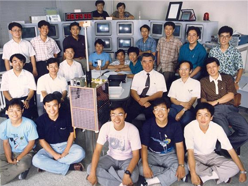 SaTReC, Birthplace of Korea’s First Satellite, Celebrates 30th Anniversary
< SaTReC researchers who developed Korea's first satellite, KITSAT-1 >
The Satellite Technology Research Center (SaTReC) at KAIST, which launched the Korea’s first satellite KITSAT-1, celebrated 30 years in operation last week. A ceremony in honor of this milestone was held on campus on October 30. With the launching of KITSAT-1 in 1992, SaTReC paved the way for space research in Korea, and helped the nation achieve technological independence and strengthen competitiveness in the field.
The ceremony was attended by over 100 affiliates from academia and industry, including the family of the late Dr. Soon-dal Choi, the first director of SaTReC also known as the father of the first Korean satellite KITSAT-1 (nicknamed “Our Star” in Korean). His family members traveled all the way from the US to Korea for the event. A plaque of appreciation was posthumously awarded to the family of former Director Choi in memory of his pioneering Korean satellite research.
Right after the establishment of SaTReC in 1989, Dr.Choi dispatched five KAIST students to the University of Surrey in the UK to develop the Korea’s first satellite KITSAT-1 under a bilateral agreement for a joint research program.
KITSAT-1, completed in collaboration with Surrey researchers, was successfully launched from the Guiana Space Center in August 1992. Through this launch, Korea became the 22nd nation to own a satellite, and launched the domestically produced follow-up satellite KITSAT-2 in September 1993.
Since then, SaTReC has developed a total of nine satellites, including three in the KITSAT series in the 1990s as well as five STSATs and one Next-Generation Small Satellite in the 2000s. These satellites are still in operation today, thanks to SaTReC’s constant maintenance.
SaTReC is still contributing to the verification of core space technologies and Earth and space observation technologies using small satellites. It is also training specialized personnel in national space research and development.
Most significantly, STSAT-2C, also commonly known as the Naro Science Satellite, was launched on January 30, 2013 and served an important role in allowing the first Korean launch vehicle Naro-1 (KSLV-1) to enter into orbit.
SaTReC researchers are now working on developing a Next-Generation Small Satellite named NEXTSat-2 that boasts a Synthetic Aperture Radar (SAR) system developed with domestic technology. NEXTSat-2 will be launched in 2022 from Korean soil, carried by a Korean launch vehicle developed with local technology.
Director of SaTReC Sejin Kwon said, “We will follow the noble spirit of the late Dr. Soon-dal Choi, who dedicated his entire life to the nation’s satellite research and bolstered our commitment to the development of Korea’s future space technology.” He added, “We will pursue our dreams of space exploration with a sense of social responsibility to pay back to society the benefits reaped from space technology.”
The ceremony was followed by a Future Space Technology Workshop, where eight KAIST professors participated as speakers.
< Timeline of Korea's Satellite Research and Development >
(END)
2019.11.05 View 7620
SaTReC, Birthplace of Korea’s First Satellite, Celebrates 30th Anniversary
< SaTReC researchers who developed Korea's first satellite, KITSAT-1 >
The Satellite Technology Research Center (SaTReC) at KAIST, which launched the Korea’s first satellite KITSAT-1, celebrated 30 years in operation last week. A ceremony in honor of this milestone was held on campus on October 30. With the launching of KITSAT-1 in 1992, SaTReC paved the way for space research in Korea, and helped the nation achieve technological independence and strengthen competitiveness in the field.
The ceremony was attended by over 100 affiliates from academia and industry, including the family of the late Dr. Soon-dal Choi, the first director of SaTReC also known as the father of the first Korean satellite KITSAT-1 (nicknamed “Our Star” in Korean). His family members traveled all the way from the US to Korea for the event. A plaque of appreciation was posthumously awarded to the family of former Director Choi in memory of his pioneering Korean satellite research.
Right after the establishment of SaTReC in 1989, Dr.Choi dispatched five KAIST students to the University of Surrey in the UK to develop the Korea’s first satellite KITSAT-1 under a bilateral agreement for a joint research program.
KITSAT-1, completed in collaboration with Surrey researchers, was successfully launched from the Guiana Space Center in August 1992. Through this launch, Korea became the 22nd nation to own a satellite, and launched the domestically produced follow-up satellite KITSAT-2 in September 1993.
Since then, SaTReC has developed a total of nine satellites, including three in the KITSAT series in the 1990s as well as five STSATs and one Next-Generation Small Satellite in the 2000s. These satellites are still in operation today, thanks to SaTReC’s constant maintenance.
SaTReC is still contributing to the verification of core space technologies and Earth and space observation technologies using small satellites. It is also training specialized personnel in national space research and development.
Most significantly, STSAT-2C, also commonly known as the Naro Science Satellite, was launched on January 30, 2013 and served an important role in allowing the first Korean launch vehicle Naro-1 (KSLV-1) to enter into orbit.
SaTReC researchers are now working on developing a Next-Generation Small Satellite named NEXTSat-2 that boasts a Synthetic Aperture Radar (SAR) system developed with domestic technology. NEXTSat-2 will be launched in 2022 from Korean soil, carried by a Korean launch vehicle developed with local technology.
Director of SaTReC Sejin Kwon said, “We will follow the noble spirit of the late Dr. Soon-dal Choi, who dedicated his entire life to the nation’s satellite research and bolstered our commitment to the development of Korea’s future space technology.” He added, “We will pursue our dreams of space exploration with a sense of social responsibility to pay back to society the benefits reaped from space technology.”
The ceremony was followed by a Future Space Technology Workshop, where eight KAIST professors participated as speakers.
< Timeline of Korea's Satellite Research and Development >
(END)
2019.11.05 View 7620 -
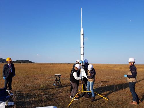 KAIST Launches Woorisae II
Professor Sejin Kwon from the Department of Aerospace Engineering and his team succeeded in launching a science rocket, named ‘Woorisae II’ at Saemanguem reclamation. This rocket was developed in collaboration with the Satellite Technology Research Lab (SaRTec).
The test-firing was conducted at 10:43 am on Sunday October 28, 2018 (35°N 42’ 06” 126°E 33’ 36”, Radius of 0.6NM). This launch was the follow-up to the previous launch that was cancelled due to not gaining approval for using the airspace.
Professor Kwon’s team put a great deal of effort into securing the land for the rocket launch. As a result, they got approval from the Saemangeum Development and Investment Agency for the land and the Ministry of Land, Infrastructure and Transport for the use of the airspace. The Republic of Korea Air Force and United States Air Force also approved the use of the airspace for the launch of the science rocket for research purposes.
Woorisae II is 2.2 meters long with a diameter of 20cm, and weighs 13kg without a payload. The rocket is powered by a hybrid rocket with hydrogen peroxide oxidizer producing 100 kg of force. The Woorisae II sounding rocket was designed to burn for five seconds and then continue inertial flight for 20 seconds. The target altitude of Woorisae II was set at 3,300 feet to comply with the airspace approval.
The team developed the core components, including a hybrid rocket propulsion system, flight computer and parachute recovery system, as well as a ground control station. The flight data was transmitted to the ground station and recorded to onboard computer memory.
When a malfunction occurs during the flight, Woorisae II was designed to terminate the power flight for safety by shutting the propellant valve and deploying the recovery parachute. All the rocket subsystems and components were developed and supplied by domestic startup companies such as INOCOM and NARA SPACE TEHCNOLOGY.
Generally, sounding rockets reach an altitude beyond 30km and are widely used for testing rocket engines and reentry materials as well as for conducting microgravity experiments. Instruments for atmospheric science can also be installed to measure fine dust and high altitude atmosphere. Besides these science and technology purposes, most advanced spacefaring countries have sounding rocket programs to train and educate young people in the field of space science.
Professor Kwon said, “We will plan to launch upgraded rockets on November 4 and December 6 because we already received approval from the related agencies for using this land and airspace. Based on the experiment, we are planning to develop a cost-efficient small launch vehicle that is capable of delivering a cube satellite into Earth’s orbit.”
(Photos of preparing the rocket launch)
2018.10.29 View 12069
KAIST Launches Woorisae II
Professor Sejin Kwon from the Department of Aerospace Engineering and his team succeeded in launching a science rocket, named ‘Woorisae II’ at Saemanguem reclamation. This rocket was developed in collaboration with the Satellite Technology Research Lab (SaRTec).
The test-firing was conducted at 10:43 am on Sunday October 28, 2018 (35°N 42’ 06” 126°E 33’ 36”, Radius of 0.6NM). This launch was the follow-up to the previous launch that was cancelled due to not gaining approval for using the airspace.
Professor Kwon’s team put a great deal of effort into securing the land for the rocket launch. As a result, they got approval from the Saemangeum Development and Investment Agency for the land and the Ministry of Land, Infrastructure and Transport for the use of the airspace. The Republic of Korea Air Force and United States Air Force also approved the use of the airspace for the launch of the science rocket for research purposes.
Woorisae II is 2.2 meters long with a diameter of 20cm, and weighs 13kg without a payload. The rocket is powered by a hybrid rocket with hydrogen peroxide oxidizer producing 100 kg of force. The Woorisae II sounding rocket was designed to burn for five seconds and then continue inertial flight for 20 seconds. The target altitude of Woorisae II was set at 3,300 feet to comply with the airspace approval.
The team developed the core components, including a hybrid rocket propulsion system, flight computer and parachute recovery system, as well as a ground control station. The flight data was transmitted to the ground station and recorded to onboard computer memory.
When a malfunction occurs during the flight, Woorisae II was designed to terminate the power flight for safety by shutting the propellant valve and deploying the recovery parachute. All the rocket subsystems and components were developed and supplied by domestic startup companies such as INOCOM and NARA SPACE TEHCNOLOGY.
Generally, sounding rockets reach an altitude beyond 30km and are widely used for testing rocket engines and reentry materials as well as for conducting microgravity experiments. Instruments for atmospheric science can also be installed to measure fine dust and high altitude atmosphere. Besides these science and technology purposes, most advanced spacefaring countries have sounding rocket programs to train and educate young people in the field of space science.
Professor Kwon said, “We will plan to launch upgraded rockets on November 4 and December 6 because we already received approval from the related agencies for using this land and airspace. Based on the experiment, we are planning to develop a cost-efficient small launch vehicle that is capable of delivering a cube satellite into Earth’s orbit.”
(Photos of preparing the rocket launch)
2018.10.29 View 12069 -
 The Center for Anthropocene Studies (CAS) Opens
KAIST will start Anthropocene research, a convergence field of study, to address issues related to the commencement of human activities that have had scientific, industrial, and economic impacts on the Earth’s ecosystem. The National Research Foundation (NRF) of Korea endorsed the KAIST Center for Anthropocene Studies as its Convergence Research Center project.
Anthropocene refers to a new geological age in which various polluting materials that humans have made during the post-industrial revolution era have made a significant impact on the Earth and the lives of humankind. The studies expand the diverse socio-economic and environmental sectors for responding to climate change, natural disasters, ecological destruction, the polarization of the inequality and wealth, and many others.
The KAIST research group at the center, in collaboration with the Graduate School of Science and Technology Policy, the Graduate School of Culture Technology, the School of Humanities & Social Sciences, the Department of Industrial Design, the School of Electrical Engineering, the Satellite Technology Research Center (SaRTec), and the KAIST Initiative for Disaster Studies will conduct multidisciplinary research to address intriguing challenges with complex but creative approaches incorporating the fields of engineering, socioeconomics, and art.
The group will investigate topics such as▲ surface and marine changes to the Earth by applying satellite data ▲disaster prediction and governance system building through AI modeling ▲sustainable housing, transportation, and lifestyles ▲ engineering and artistic approaches for envisioning a new future for humankind and the Earth.
Professor Buhm Soon Park, who is in charge of the center, said, “This pioneering research work will inspire the re-creation of a new paradigm of convergence studies in science, engineering, humanities, and social science. We will contribute to making the world better by designing new technologies and social policies.
2018.06.05 View 13905
The Center for Anthropocene Studies (CAS) Opens
KAIST will start Anthropocene research, a convergence field of study, to address issues related to the commencement of human activities that have had scientific, industrial, and economic impacts on the Earth’s ecosystem. The National Research Foundation (NRF) of Korea endorsed the KAIST Center for Anthropocene Studies as its Convergence Research Center project.
Anthropocene refers to a new geological age in which various polluting materials that humans have made during the post-industrial revolution era have made a significant impact on the Earth and the lives of humankind. The studies expand the diverse socio-economic and environmental sectors for responding to climate change, natural disasters, ecological destruction, the polarization of the inequality and wealth, and many others.
The KAIST research group at the center, in collaboration with the Graduate School of Science and Technology Policy, the Graduate School of Culture Technology, the School of Humanities & Social Sciences, the Department of Industrial Design, the School of Electrical Engineering, the Satellite Technology Research Center (SaRTec), and the KAIST Initiative for Disaster Studies will conduct multidisciplinary research to address intriguing challenges with complex but creative approaches incorporating the fields of engineering, socioeconomics, and art.
The group will investigate topics such as▲ surface and marine changes to the Earth by applying satellite data ▲disaster prediction and governance system building through AI modeling ▲sustainable housing, transportation, and lifestyles ▲ engineering and artistic approaches for envisioning a new future for humankind and the Earth.
Professor Buhm Soon Park, who is in charge of the center, said, “This pioneering research work will inspire the re-creation of a new paradigm of convergence studies in science, engineering, humanities, and social science. We will contribute to making the world better by designing new technologies and social policies.
2018.06.05 View 13905 -
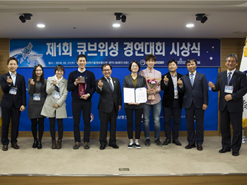 KAIST, First to Win the Cube Satellite Competition
Professor Hyochoong Bang from the Department of Aerospace Engineering and his team received the Minister of Science and ICT Award at the 1st Cube Satellite Competition.
The team actually participated in the competition in 2012, but it took several years for the awarding ceremony since it took years for the satellites to be designed, produced, and launched.
The KAIST team successfully developed a cube satellite, named ‘Little Intelligent Nanosatellite of KAIST (LINK)’ and completed its launch in April 2017.
LINK (size: 20cmx10cmx10cm, weight: 2kg) mounted mass spectrometry and Langmuir probe for Earth observation. The Langmuir probe was developed by Professor Kyoung Wook Min from the Department of Physics, KAIST.
Yeerang Lim, a PhD student from the Department of Aerospace Engineering said, “I still remember the feeling that I had on the day when LINK launched into orbit and sent back signals. I hope that space exploration is not something far away but attainable for us in near future.”
2018.02.22 View 12957
KAIST, First to Win the Cube Satellite Competition
Professor Hyochoong Bang from the Department of Aerospace Engineering and his team received the Minister of Science and ICT Award at the 1st Cube Satellite Competition.
The team actually participated in the competition in 2012, but it took several years for the awarding ceremony since it took years for the satellites to be designed, produced, and launched.
The KAIST team successfully developed a cube satellite, named ‘Little Intelligent Nanosatellite of KAIST (LINK)’ and completed its launch in April 2017.
LINK (size: 20cmx10cmx10cm, weight: 2kg) mounted mass spectrometry and Langmuir probe for Earth observation. The Langmuir probe was developed by Professor Kyoung Wook Min from the Department of Physics, KAIST.
Yeerang Lim, a PhD student from the Department of Aerospace Engineering said, “I still remember the feeling that I had on the day when LINK launched into orbit and sent back signals. I hope that space exploration is not something far away but attainable for us in near future.”
2018.02.22 View 12957 -
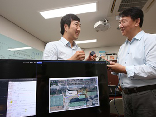 Highly Sensitive and Fast Indoor GNSS Signal Acquisition Technology
(Professor Seung-Hyun Kong (right) and Research Fellow Tae-Sun Kim)
A research team led by Professor Seung-Hyun Kong at the Cho Chun Shik Graduate School of Green Transportation, KAIST, developed high-speed, high-sensitivity Global Navigation Satellite System (GNSS) signal acquisition (search and detection) technology that can produce GNSS positioning fixes indoors.
Using the team’s new technology, GNSS signals will be sufficient to identify locations anywhere in the world, both indoors and outdoors. This new research finding was published in the international journal IEEE Signal Processing Magazine (IEEE SPM) this September.
Global Positioning System (GPS) developed by the U.S. Department of Defense in the 1990s is the most widely-used satellite-based navigation system, and GNSS is a terminology to indicate conventional satellite based navigation systems, such as GPS and Russian GLONASS, as well as new satellite-based navigation systems under development, such as European GALILEO, Chinese COMPASS, and other regional satellite-based navigation systems.
In general, GNSS signals are transmitted all over the globe from 20,000 km above the Earth and thus a GNSS signal received by a small antennae in an outdoor environment has weak signal power. In addition, GNSS signals penetrating building walls become extremely weak so the signal can be less than 1/1000th of the signal power received outside.
Using conventional acquisition techniques including the frequency-domain correlation technique to acquire an extremely weak GNSS signal causes the computational cost to increase by over a million times and the processing time for acquisition also increases tremendously. Because of this, indoor measurement techniques using GNSS signals were considered practically impossible for the last 20 years.
To resolve such limitations, the research team developed a Synthesized Doppler-frequency Hypothesis Testing (SDHT) technique to dramatically reduce the acquisition time and computational load for extremely weak GNSS signals indoors.
In general, GNSS signal acquisition is a search process in which the instantaneous accurate code phase and Doppler frequency of the incoming GNSS signal are identified. However, the number of Doppler frequency hypotheses grows proportionally to the coherent correlation time that should be necessarily increased to detect weak signals. In practice, the coherent correlation time should be more than 1000 times longer for extremely weak GNSS signals so the number of Doppler frequency hypotheses is greater than 20,000. On the other hand, the SDHT algorithm indirectly tests the Doppler frequency hypothesis utilizing the coherent correlation results of neighboring hypotheses.
Therefore, using SDHT, only around 20 hypotheses are tested using conventional correlation techniques and the remaining 19,980 hypotheses are calculated with simple mathematical operations. As a result, SDHT achieves a huge computational cost reduction (by about 1000 times) and is 800 times faster for signal acquisition compared to conventional techniques. This means only about 15 seconds is required to detect extremely weak GNSS signals in buildings using a personal computer.
The team predicts further studies for strengthening SDHT technology and developing positioning systems robust enough to multipath in indoor environments will allow indoor GNSS measurements within several seconds inside most buildings using GNSS alone.
Professor Kong said, “This development made us the leader in indoor GNSS positioning technology in the world.” He continued, “We hope to commercialize indoor GNSS systems to create a new market.” The research team is currently registering a patent in Korea and applying for patents overseas, as well as planning to commercialize the technology with the help of the Institute for Startup KAIST.
(Figure1. Positioning Results for the GPS Indoor Positioning System using SDHT Technology)
2017.11.02 View 7609
Highly Sensitive and Fast Indoor GNSS Signal Acquisition Technology
(Professor Seung-Hyun Kong (right) and Research Fellow Tae-Sun Kim)
A research team led by Professor Seung-Hyun Kong at the Cho Chun Shik Graduate School of Green Transportation, KAIST, developed high-speed, high-sensitivity Global Navigation Satellite System (GNSS) signal acquisition (search and detection) technology that can produce GNSS positioning fixes indoors.
Using the team’s new technology, GNSS signals will be sufficient to identify locations anywhere in the world, both indoors and outdoors. This new research finding was published in the international journal IEEE Signal Processing Magazine (IEEE SPM) this September.
Global Positioning System (GPS) developed by the U.S. Department of Defense in the 1990s is the most widely-used satellite-based navigation system, and GNSS is a terminology to indicate conventional satellite based navigation systems, such as GPS and Russian GLONASS, as well as new satellite-based navigation systems under development, such as European GALILEO, Chinese COMPASS, and other regional satellite-based navigation systems.
In general, GNSS signals are transmitted all over the globe from 20,000 km above the Earth and thus a GNSS signal received by a small antennae in an outdoor environment has weak signal power. In addition, GNSS signals penetrating building walls become extremely weak so the signal can be less than 1/1000th of the signal power received outside.
Using conventional acquisition techniques including the frequency-domain correlation technique to acquire an extremely weak GNSS signal causes the computational cost to increase by over a million times and the processing time for acquisition also increases tremendously. Because of this, indoor measurement techniques using GNSS signals were considered practically impossible for the last 20 years.
To resolve such limitations, the research team developed a Synthesized Doppler-frequency Hypothesis Testing (SDHT) technique to dramatically reduce the acquisition time and computational load for extremely weak GNSS signals indoors.
In general, GNSS signal acquisition is a search process in which the instantaneous accurate code phase and Doppler frequency of the incoming GNSS signal are identified. However, the number of Doppler frequency hypotheses grows proportionally to the coherent correlation time that should be necessarily increased to detect weak signals. In practice, the coherent correlation time should be more than 1000 times longer for extremely weak GNSS signals so the number of Doppler frequency hypotheses is greater than 20,000. On the other hand, the SDHT algorithm indirectly tests the Doppler frequency hypothesis utilizing the coherent correlation results of neighboring hypotheses.
Therefore, using SDHT, only around 20 hypotheses are tested using conventional correlation techniques and the remaining 19,980 hypotheses are calculated with simple mathematical operations. As a result, SDHT achieves a huge computational cost reduction (by about 1000 times) and is 800 times faster for signal acquisition compared to conventional techniques. This means only about 15 seconds is required to detect extremely weak GNSS signals in buildings using a personal computer.
The team predicts further studies for strengthening SDHT technology and developing positioning systems robust enough to multipath in indoor environments will allow indoor GNSS measurements within several seconds inside most buildings using GNSS alone.
Professor Kong said, “This development made us the leader in indoor GNSS positioning technology in the world.” He continued, “We hope to commercialize indoor GNSS systems to create a new market.” The research team is currently registering a patent in Korea and applying for patents overseas, as well as planning to commercialize the technology with the help of the Institute for Startup KAIST.
(Figure1. Positioning Results for the GPS Indoor Positioning System using SDHT Technology)
2017.11.02 View 7609 -
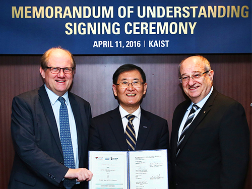 KAIST, NTU, and Technion Collaborate for Research in Emerging Fields
KAIST, Nanyang Technological University (NTU) of Singapore, and Technion of Israel signed an agreement on April 11, 2016 in Seoul to create a five-year joint research program for some of the most innovative and entrepreneurial areas: robotics, medical technologies, satellites, materials science and engineering, and entrepreneurship. Under the agreement, the universities will also offer dual degree opportunities, exchange visits, and internships.
In the picture from the left, Bertil Andersson of NTU, Sung-Mo Kang of KAIST, and Peretz Lavie of Technion hold the signed memorandum of understanding.
2016.04.14 View 13381
KAIST, NTU, and Technion Collaborate for Research in Emerging Fields
KAIST, Nanyang Technological University (NTU) of Singapore, and Technion of Israel signed an agreement on April 11, 2016 in Seoul to create a five-year joint research program for some of the most innovative and entrepreneurial areas: robotics, medical technologies, satellites, materials science and engineering, and entrepreneurship. Under the agreement, the universities will also offer dual degree opportunities, exchange visits, and internships.
In the picture from the left, Bertil Andersson of NTU, Sung-Mo Kang of KAIST, and Peretz Lavie of Technion hold the signed memorandum of understanding.
2016.04.14 View 13381 -
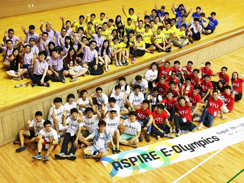 ASPIRE League 2014: E-Olympics among Five Asian Universities
About 150 undergraduate students from five leading science and technology (S&T) universities in Asia met at the KAIST campus to attend the E-Olympics on August 7-9, 2014.
The E-Olympics began as a student exchange conference held under the Asian Science and Technology Pioneering Institutes of Research and Education (ASPIRE) League, which offers a variety of events, such as workshops, sports matches, lab visits, special lectures, and art performances, to promote academic and research collaborations and cultural sharing between the students of the league member universities.
Founded in 2009, the ASPIRE League is a university consortium consisted of five top S&T universities in Asia: KAIST in Korea, the Hong Kong University of Science and Technology (HKUST) and Tsinghua University in China, Nanyang Technological University (NTU) in Singapore, and Tokyo Institute of Technology (Tokyo Tech) in Japan. The ASPIRE League aims to provide a knowledge and technology hub for innovation in Asia through the advancement of science and technology and the development of human resources.
Since its start, the ASPIRE League has been holding an annual conference with programs for research collaboration, student exchange, educational cooperation, and satellite laboratories among professors, senior managers, and students of the member universities. This year, however, the consortium decided to dedicate the conference to students by holding the E-Olympics.
Each university sent 30 students to KAIST for the participation of the E-Olympics. For three days, participating students engaged in discussions and presentations at academic workshops; held athletic games including a relay race, basketball, and a rowing race; and toured a few KAIST laboratories, among them: the E-mobility Research Center, the Bio-imaging and Cell Signaling Research Center, the Mechatronics Systems and Control Center, and the Center of Field Robotics for Innovation, Exploration and Defense.
The students also attended a music concert performed by a KAIST student club and a lecture entitled “Entrepreneurship through Global Networking” that emphasized the importance of personnel networking in transferring technological innovation into business opportunities.
Chang-Dong Yoo, the Dean of the International Office at KAIST, said, “The E-Olympics will offer students from top science and technology universities in Asia opportunities to interact with each other on a more personal level. I hope that through many of the E-Olympics programs, the students will learn about each other’s culture and academic strength and develop a sense of community to create a “New Asia” by working together.”
2014.08.11 View 14361
ASPIRE League 2014: E-Olympics among Five Asian Universities
About 150 undergraduate students from five leading science and technology (S&T) universities in Asia met at the KAIST campus to attend the E-Olympics on August 7-9, 2014.
The E-Olympics began as a student exchange conference held under the Asian Science and Technology Pioneering Institutes of Research and Education (ASPIRE) League, which offers a variety of events, such as workshops, sports matches, lab visits, special lectures, and art performances, to promote academic and research collaborations and cultural sharing between the students of the league member universities.
Founded in 2009, the ASPIRE League is a university consortium consisted of five top S&T universities in Asia: KAIST in Korea, the Hong Kong University of Science and Technology (HKUST) and Tsinghua University in China, Nanyang Technological University (NTU) in Singapore, and Tokyo Institute of Technology (Tokyo Tech) in Japan. The ASPIRE League aims to provide a knowledge and technology hub for innovation in Asia through the advancement of science and technology and the development of human resources.
Since its start, the ASPIRE League has been holding an annual conference with programs for research collaboration, student exchange, educational cooperation, and satellite laboratories among professors, senior managers, and students of the member universities. This year, however, the consortium decided to dedicate the conference to students by holding the E-Olympics.
Each university sent 30 students to KAIST for the participation of the E-Olympics. For three days, participating students engaged in discussions and presentations at academic workshops; held athletic games including a relay race, basketball, and a rowing race; and toured a few KAIST laboratories, among them: the E-mobility Research Center, the Bio-imaging and Cell Signaling Research Center, the Mechatronics Systems and Control Center, and the Center of Field Robotics for Innovation, Exploration and Defense.
The students also attended a music concert performed by a KAIST student club and a lecture entitled “Entrepreneurship through Global Networking” that emphasized the importance of personnel networking in transferring technological innovation into business opportunities.
Chang-Dong Yoo, the Dean of the International Office at KAIST, said, “The E-Olympics will offer students from top science and technology universities in Asia opportunities to interact with each other on a more personal level. I hope that through many of the E-Olympics programs, the students will learn about each other’s culture and academic strength and develop a sense of community to create a “New Asia” by working together.”
2014.08.11 View 14361